strange green light permeates the restrooms plus you can make your own wood stain and go fishing with walnutsOutdoor Appeal: 10 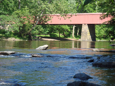
Setting: small, comfortable state park cradled in the Tohickon Creek valley
Explorable Op's: A ton. Although the park itself is small in comparison to others in the immediate area, like Nockamixon, the Tohickon Creek at Ralph Stover is easy to wade in plus High Rocks Vista section of the park is just over the bridge and up the hill. In addition there's a playground, grills, restrooms and pavilions to set up for a longer stay. It's a great place for kids to have some freedom and for parents to feel at ease that nobody will wonder off too far.
 Difficulty:
 Moderate. The park is right next to the creek and flat for the most part. If you are going in the creek or following trails along the creek the footing can get tricky because it can be rocky, slippery or both. Beware, if you go the High Rocks section of the park the terrain is
Tough. Facilities:
 Rustic. There are pit toilets up the hill of the bridge parking lot. They are not very pleasing places to visit but they do add a little adventure to the trip. One of the restroom's charms is the corrugated, green, fiber glass roof, which makes everything appear slightly green when you're inside. Your eyes do adjust. The the novelty of it is that when you come out of the bathroom the natural light looks... well, it's hard to describe. Everything looks not quite the same as when you went in. And then your eyes adjust again and you go on with your day.
 Review:
 It's hard to overstate my affection for this little slice of the Tohickon Creek. I've been to Ralph Stover countless times, with and without kids. It's a true gem in Bucks County. It's located close to a lot of other places that are worth a visit as well, so it makes it perfect place for just an hour or part of a day trip. Our last visit started out like many others. We first went to the playground. Despite the appeal of the creek, I like to push them to the playground first before they get wet.
So if you've read the "Facilities" section above you already know about the "strange green light." How about the walnut wood stain? The answer to that lies in the field next to the playground - literally. Although you'll only find them there in the fall. The area is dotted with black walnut trees which not only provide the playground area with shade, but also throw down walnuts in the fall. A friend of ours, Tim, lives just over the hill from the park. He did us the wonderful favor of refinishing a table surface. He made walnut stain from real walnut. Go figure? I don't know how it's done but if you're looking to give it a shot, Ralph Stover Park is a good place to go collecting. While I'm off topic here, I might as well reveal the walnut fishing secret. Native Americans used to throw bunches of walnuts in a creek to catch fish. Yeah, I know it doesn't seem to make any sense. But it turns out that the husk of the walnut has something in it that stuns the fish and makes them floaters. Don't try it. It takes a lot of walnuts and it's illegal.

After monkeying around at the playground we headed back to the car to eat. We parked near the pavilion above. I love that there is a fireplace! I've always wanted to bring some wood to the park and have an evening hot dog and marshmallow roast. You'll get the details when it happens. We had a picnic lunch here and the boys were fascinated with the place. There are built in steps on either side of the fireplace for staking wood. This provided a full 15 minutes of entertainment for Max and Frank. They would climb up (I had to help Frank) and then look at each other across the face of the chimney to see how high they both were - pretty cute.
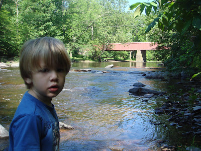
Then it was time to take a walk near the creek. Max wanted to go across the red bridge. As much as I like the park, the bridge is no fun. It has high walls on either side that you can't see over. It sort of looks like they builders were trying to mimic some kind of canal structure when they restored it. Anyway, the bridge doesn't offer much. On the other side Max found a trail that we took to the creek. The access to the water wasn't very manageable and the creek side itself was rocky so we stayed long enough to take a picture and headed back over the bridge.
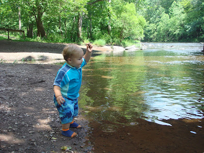
The area directly under the bridge on the park side is perfect for little kids. The shore line is bedded with tiny pebbles so it's easy to walk. There are plenty of red, flat shale rocks for skipping and the water (when the creek is low) is shallow. Plus the bridge provides shade. It's a wonderful place to let younger kids run free and let them do some exploring on their own. That being said, it is a good idea to be respectful of others that are using the space. For example, if someone is fishing under the bridge you shouldn't unleash the kids to ravage the area until the he moves on to a different spot. And even though this is a relatively safe area when the water is low you still need to be extremely conscious of what your kids are doing and where they are. Last fall I went to this same spot with the boys. Frank was only a few month old and I was carrying him in the Baby Bjorn. Max was standing on the shore line casting rocks a few feet out in the water and I was right behind him feeding Frankie a bottle. For who knows what reason, Max started walking right into the water and was quickly up to his waist. He tried to turn back to shore but fell over. I had to run in to pull him out. He was never in any real danger but I would have never expected him to do that. We'd been around the same kind of water many times and he had never done anything like that before. So be very aware and ready to play goalie.
Recommendations: First of all, there are lot of other places around to visit. High Rocks Vista (which is part of the park), Stover-Myer Mill, Cabin Run covered bridge, Van Sant Airport and Tohickon Valley Park to name a few. Tohickon Valley Park is a county park downstream from Ralph Stover State Park and it offers camping for tents, RV's and cabins plus a pool. If you are visiting in the summer, bring a bathing suit for the kids and a change of clothes. When Lake Nockamixon Dam is released hundreds of canoers and kayakers flood the park to make their way down the rapids. It's a real show and quite festive to bring the kids to see. And of course, hot dogs and marshmallows at the pavilion with the fireplace is still on my list of things to do at Ralph Stover State Park. Happy trails.


 Setting: Variably smooth to rough trails lead to the cavernous gorge which is filled by braided, cascading falls that spill over an endless glacier of boulders - a truly sublime ambiance.
 Explorable Op's: A ton. You could easily spend hours exploring just the area of the falls that the trail crosses.
 Facilities: Nada. But there is a park with port-o-potties at the bottom of the hill on Route 519, just a few minutes north of the access road for the gorge.
 Review: You'd be hard pressed to find a slice of a wilderness more beautiful than Musconetcong Gorge in this part of the world. The gorge is deep. The handsome trees are thick, tall and tower skyward. The passive contest between the water and stone fills the place with a soothing drama. It's paradise.
 But beauty has its price. The gorge is a bit more than 1/2 a mile from the parking area. This place is unforgiving. Falling in the gorge will more than likely result in an injury that will, at the very least, let you know how very quickly fun can turn into trauma. In other words, if you fall you will hit a rock. Had I known this before setting out I may have not chosen to go to the gorge. But luckily, in our case, ignorance was bliss. We started out from the parking area. You're greeted by the sign pictured at the top of the review. I slung Frank on my back and Max and I headed downhill on a trail thick with brush. Poison ivy poked out every so often and I had to steer Max away from it. The first part of the trail was a rather steep descent for a two year old. Max had the inclination to run but quickly found physics working against his agility. I believe we followed the Nature Trail to the gorge, but it's difficult to tell on the map. After the downhill the path smoothed out and flattened. It runs parallel to the Musconetcong River down in the valley. (Note - the gorge is filled by a tributary of the Musconetcong and is not labeled on the map) The trail takes a turn uphill just before you enter the gorge. You can hear the cascading falls as you climb and then, there it is! The trail rounds the edge of the gorge. It's a long way down. As you follow the trail there are a set of whopped-d-do's before you get to the gorge rock bed. Both Max and Frank were awe struck as we descended into the valley.
 The trail is well marked and easy to follow through the gorge. The trail also does provide firm footing to safely get across the gorge. But the problem is that you're not going to just stay on the trail. You're going to want to explore and the terrain goes from challenging, to rock hopping, to bouldering in a matter of feet. We set up lunch at the waterfall pictured above. The boys got their feet wet, threw rocks and ate peanut butter and jelly sandwiches. Since this area was relatively safe I tried to quickly snap a few photos. Most of my time was spent with one hand on or close to Frank. Max had enough sense to walk in the sandy areas and stay off of the larger rocks. Frank is a different story all together. Lunch didn't hold their interest for long. The trail follows one braid of the stream to a bridge that spans the water.
  This was a fun place because it gave the kids some room to move a bit more freely than the rocky trail provided. Plus, the monsoon rains from the previous Sunday made the water rush furiously underneath the bridge. On the other side of the bridge there is a place to get close to the falls. It gave us another place to throw leaves and sticks in the water and wish them good luck on their voyage down the gorge.
 By the time we started heading back to the picnic area we had set up at our chosen waterfall, Max was getting tired and Frank was getting feisty. Frank didn't want to be restrained anymore and was determined to break free. Since Frank really couldn't be left to do what he wanted, I just tried to distract him by giving him a small stone to play with until I could get Max moving. I told Max to crawl instead of walking. I don't know why I never thought of this on our other treks where the terrain was rough. It made moving around easier for him, he wasn't in danger of slipping and falling (at least not more than a few inches) and he thought it was fun. With Max rejuvenated and making his own way again, I then took Frank and put him on top of a big boulder - about 5 feet high - and let him check it out. I still had a hold on him the whole time but he was too impressed by how high up he was to notice me.
 One of our last attempts at exploring the area was a quick dip in the waterfall. Max really wanted to touch it. The waterfall where we set up had a very sandy shore and pool bed. The water was only about a foot to 2 deep next to the falls so I decided it was a safe bet. We started to make our way into the water towards the falls together but we only got up to our ankles before Max and Frank both decided that it was too cold and maybe a little scary. So we turned back to the shore, put on our shoes and headed back to the car. Hiking back was tough because I had to carry both Max and Frank for most of the 1/2 mile. It's probably the best workout I've had all year. We got drinks, got ourselves in the car and headed out. I wanted to check out the valley that Route 519 runs through so we followed the access road down instead of heading back up Dennis Road. Fiber Mark, which I believe is a paper mill, is visible from the bridge that crosses the Musconetcong River. Going just a little further north you come to a T where 627 and 519 join. If you turn right there is a park with a pavilion and sports fields on your left. We pulled in there to finish our lunch, go to the bathroom and play chase around the picnic tables before we got back in the car to go home.
 Recommendations: Carry a phone with you and keep it on you while you explore - not in your backpack or elsewhere. Be honest with yourself about your ability and your kids' abilities to make good decisions in the gorge. Take a camera. You can get some spectacular shots if you have time. If you are taking a picnic, the park at the intersection of routes 519 and 627 is a nice place to relax. There is a water fountain, a pavilion with picnic tables and port-o-potties. Although we didn't stop, Jimmy's drive-in on 519 looked like a swell place to take the kids for a treat. As always, enjoy and happy trails.
 Setting: old barn converted to a stunning self-serve nature center, smooth hiking trails, a brook, bird blinds, a pond and a waterwheel
 Difficulty: Easy. Although we have not explored all of the trails and property at Honey Hollow, it seems that most of the treks are short, flat and relatively uncluttered by roots and rocks.
 Review: This is a must for a Bucks County outdoor enthusiast with kids. We've gone several times and it's always been fun. Walking into the nature center is like walking into a cathedral. The high ceiling brings you to silence. Timbers show off the skeleton of the b
 dn't get down to the steam, but there are other trails for creek exploration on the property. The next stop were the docks. There are two docks on the far side of the pond. We could see sunfish from both and had a good time looking at our reflections in the water. Moving on from the docks the hike gets slightly more challenging with a few hills. You can complete the loop around the pond by crossing the inlet stream and heading back to the nature center or you can continue on a path that follows the stream to where it crosses the gravel road that runs through the property. We checked out the inlet stream but instead of crossing it, we back tracked and took the path that follows the stream. We made it back to the gravel road and hiked back up the big slope to the nature center. The whole walk from start to finish took about 45 minutes. The back of the nature center has a large slate covered patio. We set up there for lunch. It was a perfect place for the boys to run around and eat at the same time. Once we finished lunch we headed back into the nature center to take a last look at some of the curiosities we found. We signed the guest registry and we were on our way.


